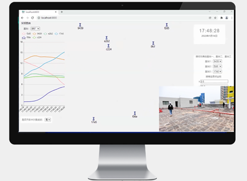
UWB self-organizing network refers to an self-organizing network based on ultra wideband technology. Ultra wideband is a short distance, high-speed, low-power, and high-precision wireless communication technology. Nodes in the network can be automatically discovered, connected, and organized without relying on fixed infrastructure, with strong flexibility and adaptability.

The positioning of firefighting and rescue personnel is mainly achieved through UWB (ultra wideband) self-organizing network through the following methods:
1. Signal transmission: UWB equipment emits and receives extremely narrow pulse signals with good time resolution, which can accurately measure signal transmission time.
2. Base station layout: Reasonably arrange multiple UWB base stations around the rescue site or within buildings.
3. Tag carrying: Fire rescue personnel wear positioning tags with UWB function.
4. Distance measurement and positioning: The tag communicates with multiple base stations, calculates the distance to the base station by measuring the time difference between the signal and the base station, and then uses algorithms such as triangular or multilateral positioning to determine the specific location of rescue personnel in space.
5. Real time update: The system continuously interacts and calculates signals, updates the location information of rescue personnel in real time, so that the command center and other relevant personnel can keep track of their dynamics at any time.
6. Data transmission: Real time transmission of positioning data to the command platform through wireless networks and other means, achieving visual display and monitoring.
7. Anti interference capability: UWB technology has strong anti-interference ability and can maintain relatively stable positioning performance in complex firefighting and rescue environments.
1. Remote scheduling monitoring
Remote real-time control of on-site data and location information for scientific and accurate coordination and scheduling.
2. UWB gateway
Obtain all location information and alarm information for real-time local presentation and feedback to the cloud. Compatible with Beidou RTK positioning, converting label vector coordinates to WGS84 coordinate system.
3. UWB positioning label
Label worn by rescue personnel. The localization tag adopts AI self-organizing network method, self-learning, and forms a network with N nearby tags to locate and transmit back to the UWB gateway.
1. Real time location display
Real time display of personnel location information in specific areas.
2. Mutual perception and positioning of positions
Real time mutual confirmation of the positions of personnel in the space area can be achieved, and absolute WGS84 geodetic coordinate system conversion can be achieved based on the calibration and conversion of Beidou RTK positioning.
3. Precision rescue
After the tag terminal triggers emergency mode, space team members can quickly and accurately confirm the location and implement emergency measures.
No on-site deployment of equipment is required. By wearing UWB devices and self-organizing the network, AI calculates the location of rescue team members.
To achieve edge computing, the temporary command center can develop on-site rescue plans by analyzing the location of relevant rescue personnel.
The temporary command center can transmit relevant information back to the rescue command center through 4G/5G and BeiDou satellite communication (if mobile communication is disrupted).
1. System settings
The system administrator performs some routine settings and operations on the system, including account management and map management. Account management mainly involves operations such as adding, deleting, modifying, querying, and assigning permissions to system visitors.
2. Location monitoring
Real time viewing of personnel positions in the system, marking their offline or online status, recording their movement trajectory, and performing trajectory playback, etc; Set up targeted electronic fences and monitor their location in real-time.
3. SOS alarm
If there is an abnormality on site, wearing a UWB tag can promptly trigger a one click SOS alarm.
1. Mobility and convenience
No wiring, no installation, no debugging, seamless connection for fast implementation of network positioning.
2. High positioning accuracy
The static accuracy of Beidou positioning can reach up to 10cm, and the UWB ranging positioning accuracy is also 10cm. The combined accuracy can generally achieve an accuracy of less than 50cm.
3. Wide coverage
UWB belongs to the communication technology in the medium and short distance range, which is very suitable for building indoor positioning systems. At present, the coverage distance of UWB base stations can reach 200 meters.
Copyrights© Shenzhen Skylab Co.,LTD All Rights Reserved.

